
No, not a spelling error. What we know as the great Yadkin River was called "Atkin" by the local Indians. In 1753, following a month of searching through the Carolina backwoods wilderness, Moravian Brother Joseph Spangenberg was directed from the west, by one of his guides, eastward toward the "Atkin River". They missed the path and ended up near current day Blowing Rock. They became lost again realizing they were following the New River. Following months of searching, walking runs which became small creeks then larger creeks ultimately joining the Atkin River near Mulberry Fields (The Current Wilkesboros). The first white people they had seen in weeks told them of large tracks to the east on the three forks of Muddy Creek. It is very likely that they were directed to cross the Atkin at the Shallow Ford. Hence the Atkin's Shallow Ford played a major part in the choice of what would become the 100,000 acre Moravian land of Wachovia in what we now know as Forsyth County the home of our Salem. The Yadkin's Shallow Ford would play a great part in the development of the Wachovia tract. For a most simple river crossing you must travel toward the Shallow Ford.
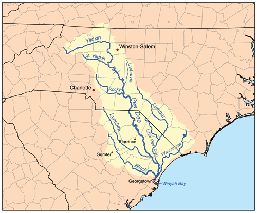
The Yadkin is one of the longest rivers in North Carolina, becomes the Pee Dee and the confluence of the Uwharrie then flows into South Carolina at the fall line near Cheraw where it becomes the Great Pee Dee River flowing to the Atlantic Ocean.
 |
| The Yadkin River - Pilot Mountain in the Background! |

No comments:
Post a Comment
Love to have your comments here.
Because of the nature of this blog, all comments are moderated and will not appear until they are reviewed. All comments will be approved unless they are found to be blatantly inappropriate, vulgar, and abusive or attempt to reveal the identity of anyone involved with this blog. NO comment with a commercial link will be accepted!